


Take Control of Your Stockpiles
Gain visibility and command over essential inventory reserves
Take Control of Your Stockpiles
Gain visibility and command over essential inventory reserves
Volumetric Analysis & Material Auditing
Precise measurement of material stockpiles and excavation volumes ensures accurate billing and prevents material theft.
Measurement Accuracy
Average Savings
Case Study: Bradbury Dam
Drone volumetric analysis identified a significant discrepancy between ordered and delivered materials, resulting in $3,500 in recovered costs.
"The drone data savings in just that story alone was significant."
Workflow

Data Analysis
We create 2D map mission for consistent orthomosaic data acquisition.

Data Processing
We utilize DJI Terra for processing, generating a high-accuracy dense Point Cloud from the collected data.

Data Analysis
We measure stockpile volumes efficiently with DJI Terra. Alternatively, import the Point Cloud data directly into third-party software for comprehensive cut and fill analysis.
Tier I: Essential
$299
Per Stockpile
Single-site stockpile measurement
Volume calculation report
Orthomosaic map
5-day delivery
Tier II: Premium
$599
Per Stockpile
All Essential features
3D digital twin model
Material classification
48-hr priority processing
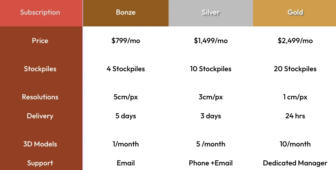
Subscription
Price
Stockpiles
Resolutions
Delivery
3D Models
Support
Bonze
$799/mo
4 Stockpiles
5cm/px
5 days
1/month
Silver
$1,499/mo
10 Stockpiles
3cm/px
3 days
5 /month
Phone +Email
Gold
$2,499/mo
20 Stockpiles
1 cm/px
24 hrs
10/month
Dedicated Manager
***All pricing assumes stockpiles <25m height and <5 acres. Complex sites require custom quote.

Our team is here to answer your questions and help you get started on turning your vision into reality.
Services
Construction
Real Estate
Inspections
Agriculture & Environment
Public Safety
Company
About Us
Portfolio
Pricing
FAQ
Legal
Privacy Policy
Terms of Service
Drone Policy
Safety Standards
© 2025 Horizon 3d Aerial . All rights reserved.
Services
Progress
Reports
As-Built
Documentation
Safety Compliance
Orthomosaics
Stockpile Management
Company
About Us
Portfolio
Pricing
FAQ
Legal
Privacy Policy
Terms of Service
Drone Policy
Safety Standards
© 2025 Horizon 3d Aerial . All rights reserved.